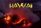
| February 2005 Paul-Edouard BERNARD DE LAJARTRE Home - Reunion |
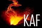
ERUPTION PITON DE LA FOURNAISE FEBRUARY 2005![]()
Pictures Gallery
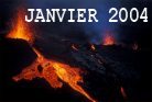
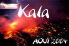
3months and a half after the eruption of Piton Kala October 2004, The sismic activity
of La Fournaise indicated an upcoming eruption.
Since February 2004 the volcanologic Observatory recorded 10 to 50 small earthquakes per day,
with a progressive inflation of the summit zone.
On february 17th in the morning, the Observatory confirmed an upcoming eruption, north of the "Enclos Foucque",
due to the important inflations recorded in "La Soufriere".
In the early afternoon, a first sismic crisis brought the Observatory to declare a alert of level 1.
At 5:30pm the crisis begun implying an imminent eruption.
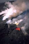
Around 8:30pm, the alert level is 2, an eruptive break opened between 1700 and 1500 meters of altitude,
on the west gradients of the Osmunds Plain.
For several days, torrential rains and extremely violent storms hit Reunion Island
bringing numerous landslides and floods, impiding the acces to the capital (St Denis) from the west.
In these difficult conditions Alain Gérente and myself left for the "Grand-Brûle".
The glimms of the eruption reflected onto the clouds setting the sky on fire in the half Est of the island.
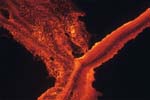
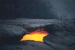
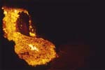
We arrived shortly after midnight on the site and disovered that the lava flow, a 100 meters long,
was about to flow down the gradient of the Osmunds Plain. Around 3:00am, the lava flow
stopped at 350 meters, 2 kilometers from the "Road of lavas" (RN2).
The eruptive break, situated 6km from the road, could nevertheless be seen clearly from it.
On Friday 18th, the terrible weather kept devastating Reunion Island,
But in spite of these conditions, Alain Gerente and I decided to attempt flying over the eruption
by helicopter. We had to fly along the coast at a very low height because of the lack of visibility
to finally reach the site of the eruption around 6:00pm.
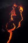
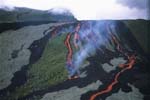
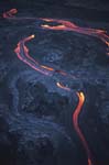
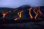
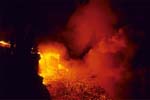
Luckily the eruption area was pretty clear. 2 openings were still very active and
gave birth to 2 very fluid lava flows of 4km reaching the altitude of 800 meters.
The front of the flow stopped at 1500 m from the road.
After flying over the eruption for a half hour, the weather caught us and we had to leave.
Saturday the 19th in the morning, only one opening remained active. The lava flows could not be seen anymore
from the road and must have spreaded in the Osmunds Plain.
In the night of the 21st and 22nd, the fishmen and locals of Bois-Blanc observed glimmers
in the Osmunds Plain anouncing the second phase of the eruption.
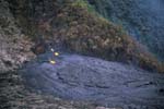
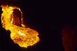
The first flying over by Helicopter on February 22 in the early morning, allowed us to observe a very fluid lava flow
at 1200 m of altitude in the Osmunds Plain down the rampart of "Bois-Blanc"
(the lava is flowing through a tunnel).
Wednesday 23rd of February in the afternoon, we could see the lava flows again from the road situated 3km away
in the strong gradients over the forest of "Grand Brule".
The following day in the early afternoon Alain Gérente and I went as usual on the eruption.
We flought from the "Grand-Brule" till 1200m of altitude landing sometimes by several skylights
in order to film and take pictures as close as possible.
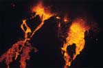
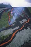
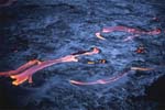
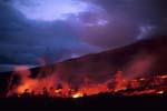
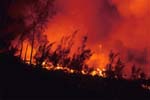
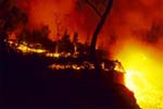
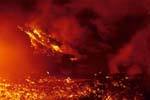
We decided to spend the night in the Osmunds Plain where over a dozen of flows ran down the last strong gradients
of the Plain swallowing the forest of "Grand-Brule". An amazing show !!!
in the night of the 24th and the 25th around 3:00am we heard a rumbling reminding of the sound
of a jet engine : The eruptive break situated between 1700 and 1500 m of altitude was active again.
At the same time, the flows stopped one after the other and only 2 flows remained active.
We got back on the helicopter around 7:30am in order to discover the source of the noise still audible.
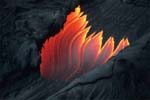
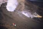
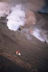
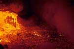
Reaching the eruptive break we noticed a new break had opened down the 2 cones of last week.
From this break extremely violent gases, ash plumes and some 100m high projections were escaping
with a cacophonous sound reminding of a plane taking off that we could here so clearly 3 miles away earlier in the night.
After a half an hour on the site of the eruption we had to leave, once again because of the unfriendly weather masking
the visibility of the flows. The other exit point of lava situated at 1200 m of altitude seemed to weaken.
On Friday 25th around 5:00pm Fountains of lava were springing out on the heights of "Grand Brule" at 1200 m of altitude.
Surprisingly, an extremely fluid lava flow ran down the gradients and through the road at 8:00pm.
We were able to reach the ocean a half hour before the flow rapidly hits the ocean at 11:45pm.
The show is dantesque.
That night some earthquakes could be felt in "Bois-Blanc", and a lava flow appeared at as low as 450m of altitude
down the "Trou Caron", against the rampart of "Bois-Blanc" 3 km from thr road RN2.
Saturday 26th, this new lava flow began slowly in the morning then suddenly accelerated in the early afternoon.
This flow is 200 m wide and crossed the RN2 at 5:25pm on the site of the « Vierge au Parasol » moved in emergency
some time earlier. The new lava flow reaches the ocean at 5:00pm.
Around 10:00pm, the « Trémor » indicating the volcanic activity slows down abruptly.
The eruption is over, even if some flows coming from the tunnels remained till Sunday the 27th.
 |
 |
 |
 |
 |
| C08.jpg | C11.jpg | C14.jpg | C18.jpg | C20.jpg |
 |
 |
 |
 |
 |
| C24.jpg | C26.jpg | C28.jpg | C29.jpg | C30.jpg |
 |
 |
 |
 |
 |
| C34.jpg | C36.jpg | C38.jpg | C39.jpg | C41.jpg |
 |
 |
 |
 |
 |
| C43.jpg | C47.jpg | C48.jpg | C49.jpg | C50.jpg |
 |
 |
|||
|
|
C56.jpg |


![]()